Home / Where / Lake Erie western basin
Lake Erie western basin
Walleye and yellow perch off Catawba, Marblehead and the Bass Islands. ODNR’s guide opens both of its winter passages with the same condition: in years with sufficient ice.
No ice report here. We don’t know the ice on any Ohio water today, and nothing on this page says you can walk on it. Read ice safety first, and check the ice yourself, every few steps, every trip.
What does ODNR say about ice fishing on Lake Erie?
“Ice fishing is an activity where anglers catch fish through an opening cut or drilled into the ice. Portable shelters, called ice shanties, are set up directly over the fishing hole for warmth and protection.”
“Walleye, white perch, and yellow perch are common ice fishing catches in Lake Erie.”
ODNR’s Lake Erie fishing guide, under WINTER WALLEYE (DECEMBER - FEBRUARY)
(ODNR (PDF)):
“In years with sufficient ice, anglers pursue walleye as they make their way back to the spawning grounds. Early in the winter, start off fishing near Catawba Island and end the season off the reef complex west of the Bass islands and north of Camp Perry firing range. Fish with ice fishing lures tipped with minnows, fished just off the bottom.”
And under WINTER PERCH (DECEMBER - FEBRUARY)
(ODNR (PDF)):
“Fishing for perch during colder months is popular, especially in years with sufficient ice. Anglers use light jigs tipped with minnows or wax worms fished near the bottom. Anglers in the western basin usually target near Catawba, the Bass islands, Marblehead, Sandusky Bay, and harbor areas.”
Both passages begin with the same condition, sufficient ice, and neither says when that is. More on the fish: what bites through the ice.
What does the Coast Guard say about this ice?
The Coast Guard’s Great Lakes district:
“Never assume the ice is safe, even if others are on it. Evaluate conditions for yourself and exercise sound judgement.”
“Stay away from shipping lanes and other areas with vessel traffic, as ice is even more unstable and unpredictable in these areas.”
Sector Buffalo: “Never assume the ice is safe, even if others are on it,” said Sector Buffalo Commander Capt. Mark Kuperman. “Ice conditions are highly unpredictable this year, and where you may have safely gone on the ice last year, may be entirely different and unsafe this year.”
(U.S. Coast Guard release, February 9, 2023)
The full set of warnings, and what to carry, is on the ice safety page.
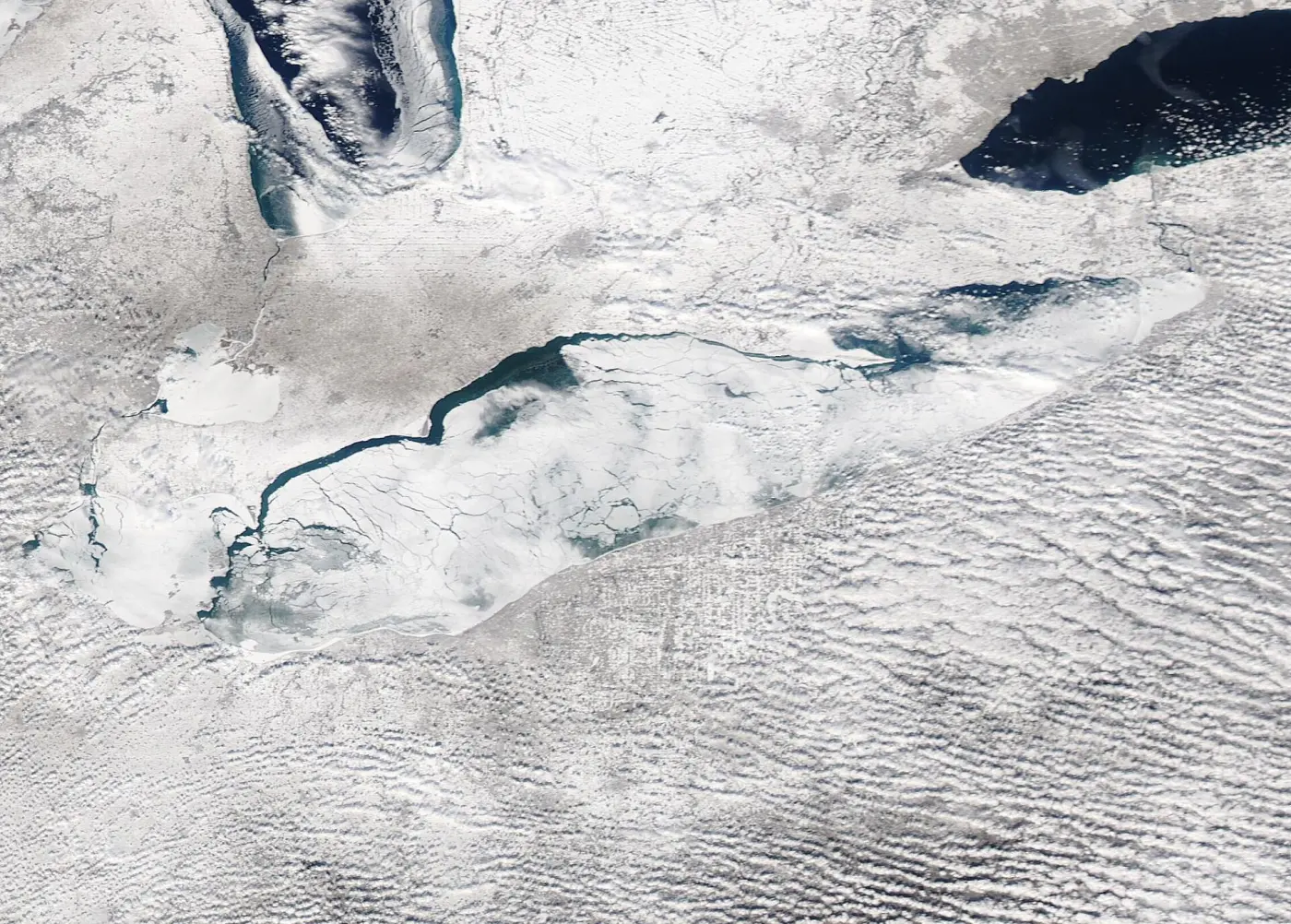
Each year, frigid winter chill brings a topping of ice to the Great Lakes while wicked winter winds force thin ice to shift, breaking it up, and expanding the extent of open water.Photo: MODIS Land Rapid Response Team, NASA Goddard Space Flight Center, public domain, via Wikimedia Commons. NASA dates the image February 14, 2022. It is one day in one past winter and says nothing about the lake now.

What does Ohio require of guides here?
A state license: No person shall be or serve as a fishing guide in the Lake Erie fishing district without a license from the chief of the division of wildlife.
(codes.ohio.gov) Fishing guide licenses shall expire each year on the fifteenth day of April.
(codes.ohio.gov) We don’t list guides. The regional visitors bureau says: Lake Erie Shores & Islands has what you need for a memorable day on the ice, including ice fishing guides and resources.
(Lake Erie Shores & Islands)
Where does ODNR list public access?
These are public access sites with street addresses in ODNR’s Lake Erie fishing guide, in the area its winter passages name. ODNR lists them as fishing access sites; the guide doesn’t call them ice entry points.
- Catawba Island State Park
Catawba Island State Park | 4049 East Moore’s Dock Road, Catawba
(ODNR (PDF))Directions Apple Maps - East Harbor State Park
East Harbor State Park | 1136 Buck Road, Marblehead
(ODNR (PDF))Directions Apple Maps - Mazurik Access Area
Mazurik Access Area | 8957 North Shore Road, Marblehead
(ODNR (PDF))Directions Apple Maps - South Bass Island State Park
South Bass Island State Park | 1523 Catawba Avenue, Put-in-Bay
(ODNR (PDF))Directions Apple Maps - Kelleys Island State Park
Kelleys Island State Park | 920 Division Street, Kelleys Island
(ODNR (PDF))Directions Apple Maps
Directions links open Google Maps or Apple Maps with the address the source prints; on a phone they may open the maps app or your browser. A listed ramp or park is where the source says the public can reach the lake. It is not a statement about ice there.
South Bass Island ice ramps
ODNR’s coastal access guidebook lists two ramps on the island by name, and gives their coordinates as 41.6580, -82.8298 (North) 41.6538, -82.8372 (South)
(ODNR Coastal (PDF)):
“There are two publicly accessible ice ramps located along West Shore Boulevard on the west side of South Bass Island. Both sites are utilized as emergency boat launches and for paddling, fishing, and winter lake access.”
- South ramp
West Shore Boulevard, south of Mitchell Road
(ODNR Coastal (PDF))Search: Google MapsApple Maps - North ramp
West Shore Boulevard, northeast of Portsmouth Road
(ODNR Coastal (PDF))There are no amenities at the north ramp.
(ODNR Coastal (PDF))Search: Google MapsApple Maps
The search links look the name up in Google Maps or Apple Maps. Results are not verified access points, so confirm with the park before you go.
ODNR on winter use of its Lake Erie access sites in general: Many Lake Erie public access sites allow a variety of winter-related activities and sports, including ice skating, ice fishing, sledding, cross-country skiing, and snowmobiling.
(ODNR Coastal (PDF))
Ohio DNR’s East Harbor State Park page: Under the proper conditions, park visitors can enjoy snowmobiling, ice skating, ice fishing, ice boating, and cross-country skiing.
(Ohio DNR park page, read in a browser November 11, 2026)
Read November 11, 2026; do not rely on it after December 26, 2026.
Ohio DNR’s website refuses automated readers, so its park pages were read in a web browser on November 11, 2026 and each sentence quoted from them was matched on the page then. We let that reading stand for 45 days, through December 26, 2026. After that date this page hides those passages in your browser and shows a notice in their place, and the next build of the site removes them, unless the park pages have been read again. With JavaScript off the passages stay, which is why each carries its own date line.
What are the rules on Lake Erie?
- Hole size:
In the lake Erie fishing district, it shall be unlawful for any person to cut or fish through a hole in the ice which has a width that exceeds twelve inches.
(codes.ohio.gov) - Tip-ups:
Throughout the state, it shall be unlawful for any person to use more than six tip-ups while fishing through the ice.
(codes.ohio.gov) - Walleye length:
It shall be unlawful for any person to take or possess a walleye, sauger, or saugeye less than fifteen inches in length while on the following bodies of water:
(codes.ohio.gov) The list that follows includesLake Erie sport fishing district;
(codes.ohio.gov) - Daily limits for walleye and yellow perch on Lake Erie:
Bag limits for walleye, sauger or saugeye and yellow perch will take effect on May first each year.
(codes.ohio.gov)The bag limits will be posted on the Ohio division of wildlife website at wildohio.gov, in a statewide news release, and in a printed pamphlet prior to May first.
(codes.ohio.gov)
Licenses, shanty marking and the other rules we quote: rules.
Lake Erie western basin: has the air been freezing?
Air temperature observed at Port Clinton Carl R Keller Field Airport (National Weather Service station KPCW, about 10 miles from the forecast point), and the Weather Service’s hourly forecast for the South Bass Island ice ramp coordinates ODNR prints.
The numbers load here from the National Weather Service when JavaScript is on.
- National Weather Service forecast for this point
- Station KPCW: recent observations
- NOAA GLERL: Great Lakes ice cover
- U.S. National Ice Center: Great Lakes ice charts
- National Weather Service Cleveland: marine forecasts
Weather is not ice thickness. This panel reads air temperature and can’t see ice, so it never tells you ice will hold. Minnesota DNR on what else matters, and by how much ice varies: Temperature, snow cover, currents, springs and rough fish all affect the relative safety of ice.
(Minnesota DNR) Ice is seldom the same thickness over a single body of water; it can be two feet thick in one place and one inch thick a few yards away.
(Minnesota DNR) How the numbers are worked out · Stations and points · Ice safety